


Services Offered by VSSE

- Urban Mapping, Land Management and Surveillance
- Detailed 3D Modelling
- Traffic Management
- Environmental Monitoring, etc.
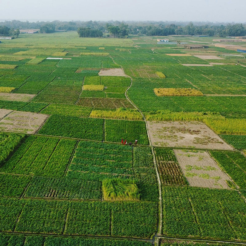
- Agricultural Analysis
- Crop Monitoring Etc.
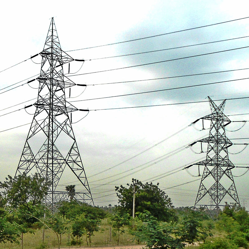
- Powerline Inspection
- Transmission Line Surveillance
- Detecting faulty lines, hotspots; etc.
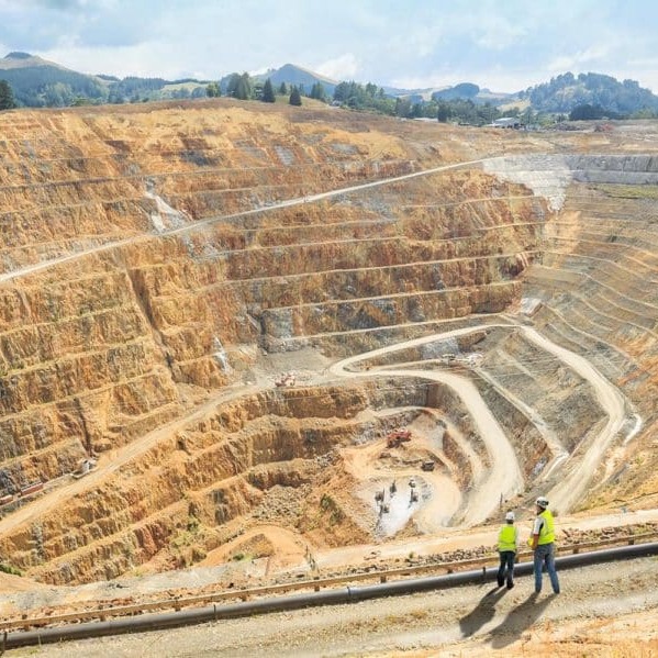
Mining Survey
Volumetric Assessment of Mines, stockpiles;
Preparation of Mine plan; Etc.
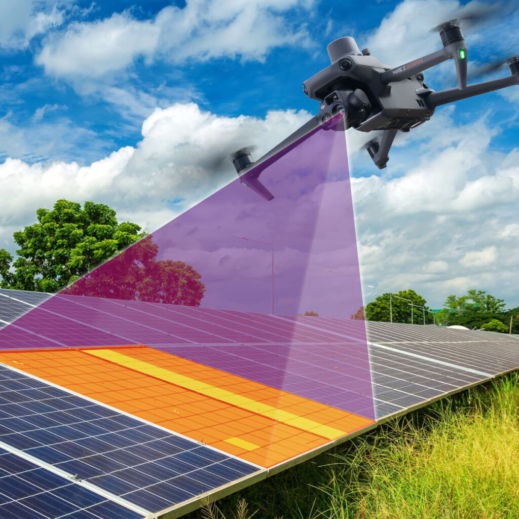
Aerial Inspection of solar power plants
Aerial Inspection of solar power plants;
Solar panel Inspection, Real time surveillance of solar farm; Detecting hotspots; etc.

Security and Surveillance
Security & Surveillance;
Traffic Management;
City Surveillance;
Heritage Surveillance;
Incident capturing at inaccessible areas, etc
About Us
VS Safety Enterprise is an India based company with head quarter in historical city of Jaipur in the state Rajasthan. It was established 3 years ago, in Aug 2020.
VS Safety Enterprise started it entrepreneurial journey with providing industrial safety solutions and products to government sectors and private enterprises.
VSSE DRONES
VIEW FROM OUR LENS

VS Safety Enterprise has India’s best mapping and surveillance category drones. Along with the drones, we have high quality imported survey equipment.
CLARITY OF VISION AND DECISION

Next-Gen Mine Surveying: Advanced Drone Solutions for Precision Mapping & Reporting
In the rapidly evolving landscape of the Indian mining sector, staying ahead requires more than just traditional methods. Our comprehensive Drone as a Service (DaaS) model provides mining enterprises with high-fidelity data, ensuring operational efficiency, safety, and strict regulatory compliance. From the rugged terrains of a Rajasthan mine to large-scale industrial quarries, our aerial intelligence transforms how you manage your assets.
Precision Mine Survey & Drone Mapping Solutions
Traditional surveying is time-consuming and often hazardous. Our Drone survey and Drone mapping services utilize state-of-the-art UAVs to capture high-resolution geospatial data in a fraction of the time. By deploying a DJI Survey workflow or utilizing a Make in India drone, we generate accurate 3D models and orthomosaic maps that serve as the foundation for your entire operation.
Key Applications:
- Topographic Mapping: Detailed contour maps for site layout and drainage.
- Haul Road Optimization: Analysis of road grades and widths to reduce fuel costs and equipment wear.
- Safety Monitoring: Identification of unstable slopes and hazardous zones without risking personnel.
Accurate Stockpile & Volumetric Estimation
Inventory management is the backbone of mining profitability. Our Stockpile estimation services eliminate the guesswork and human error associated with manual GNSS surveying.
Using advanced photogrammetry and LiDAR, we provide Volumetric estimation with centimeter-level accuracy. This data is critical for:
- Monthly Production Tracking: Reconciling excavated material against planned targets.
- Financial Auditing: Providing auditable, timestamped digital records of your inventory.
- Logistics Planning: Optimizing the movement of ore and overburden.
Comprehensive Mine Report & Regulatory Compliance
Compliance is no longer optional. Under recent mandates, such as the Rajasthan Minor Mineral Concession Rules, a detailed Mine Report backed by aerial data is mandatory for lease renewals and annual submissions.
We provide end-to-end support for:
- IBM SOP Compliance: Ensuring all survey data meets the strict standards of the Indian Bureau of Mines.
- Digital Elevation Models (DEM): High-precision terrain data required for statutory reporting in any Rajasthan mine.
- Boundary Demarcation: Legally defensible maps that ensure your operations remain within your lease boundaries.
Specialized Surveys for the Mining Lifecycle
Our expertise extends beyond daily operations into the strategic phases of mine development:
Mine Auction Survey
Before bidding, you need certainty. A Mine auction survey provides high-resolution data on topography, existing infrastructure, and mineral potential, allowing for competitive and informed bidding strategies.
Mine Planning Survey
Effective design starts with accurate data. Our Mine planning survey services provide the 3D intelligence needed for pit design, waste dump placement, and infrastructure development, ensuring long-term operational viability.
Why Choose Our Drone Services?
- Indigenous Technology: We prioritize the use of a Make in India drone to support local innovation and ensure easy maintenance and compliance with DGCA regulations.
- Advanced Hardware: For ultra-high precision, we utilize the latest DJI Survey equipment, including the Matrice 350 RTK and Mavic 3 Enterprise series.
- Expert Analysis: Our GIS team doesn’t just deliver photos; we deliver actionable intelligence through comprehensive reports and data formats compatible with your existing planning software.
Ready to digitize your mining operations? Contact us today for a consultation on how our Drone as a Service can streamline your next Mine survey.
VS Safety and Drones: India’s Premier Drone Survey & Industrial Inspection Experts
Established in 2019, VS Safety and Drones is a pioneer in high-precision aerial intelligence. We specialize in delivering data-driven solutions that bridge the gap between advanced drone technology and industrial safety. From topographic GIS mapping to complex infrastructure inspections, we provide the accuracy businesses need to make informed decisions.
Our Core Specialized Services
We leverage a fleet of state-of-the-art UAVs to offer a comprehensive suite of services across India:
- Industrial Inspections: Specialized powerline, solar thermal, and wind turbine inspections.
- Surveying & Mapping: High-resolution 3D modeling, volumetric analysis, and topographic GIS surveys.
- Infrastructure & Smart Cities: Precision road surveys, mining assessments, and urban planning data.
- Safety & Surveillance: Real-time security monitoring, flood assessment, and crop health analytics.
- Creative Excellence: Professional aerial photography and cinematic videography for commercial projects.
Why Choose VS Safety and Drones?
- Unmatched Precision: We utilize the latest sensor technology to ensure centimeter-level accuracy in every data point.
- Safety-First Culture: Our operations are rooted in stringent safety protocols, ensuring risk-free data collection in hazardous environments.
- Pan-India Presence: Headquartered in Jaipur, we maintain a robust operational network across Udaipur, Lucknow, Haryana, Uttarakhand, Mumbai, Rajkot, and Srinagar.
Where Precision Meets Safety. At VS Safety and Drones, we don’t just capture data; we drive innovation and efficiency for the future of Indian industry.